
Garmin inReach Explorer+ (010-01735-10) Satellite Communicator with Maps and Sensors
Description
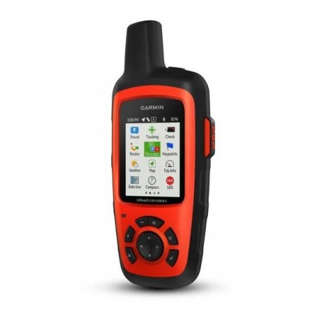
Garmin inReach Explorer+ 010-01735-10: Satellite Communicator with Enhanced Mapping and Sensors
Part Number: 010-01735-10
Sensors and TOPO Mapping: Yes
The Garmin inReach Explorer+ is an advanced handheld satellite communicator designed for adventurers who want to stay connected anywhere on Earth. With comprehensive mapping, tracking, and navigation features, it's perfect for those who venture off the grid.
- Global Communication: Enables two-way text messaging via the 100% global Iridium® satellite network (satellite subscription required).
- Interactive SOS: Trigger an SOS to the 24/7 search and rescue monitoring center for emergency assistance.
- Location Tracking: Share your location with family and friends, and let them follow your journey.
- Mobile Device Pairing: Pair with compatible mobile devices using the Earthmate® app for access to downloadable maps, U.S. NOAA charts, and color aerial imagery.
- Enhanced Mapping: Preloaded with DeLorme® TOPO maps, featuring on-screen GPS routing, a digital compass, barometric altimeter, and accelerometer.
Explore the wilderness with peace of mind, knowing you can stay in touch with loved ones or send an SOS in case of emergencies. With the ability to communicate, navigate, and share your journey, the inReach Explorer+ is an indispensable tool for outdoor enthusiasts.
Explore Anywhere. Communicate Globally.
Utilizing the Iridium satellite network's worldwide coverage, the inReach Explorer+ allows you to exchange text messages with any cell phone number or email address. Use GPS to track and share your journey's progress, post to social media, or communicate inReach-to-inReach.
In emergencies, trigger an SOS to the 24/7 monitoring center, text about the situation, and receive confirmation when help is on the way.
No Cell Tower? No Phone Service? No Problem.
The inReach Explorer+ provides the tools to stay connected, even beyond cell tower reach. Two-way messaging is possible via the global Iridium satellite network, ensuring you're always in touch.
Track and Share Your Whereabouts
Activate the tracking function and let family and friends follow your progress online using the MapShare™ portal. Send waypoints at preselected intervals, allowing followers to track your location. Invite others to ping your device, see your GPS location, and exchange messages during your trip.
Pair with Your Mobile Device
The free Earthmate® app syncs your inReach handheld with your Apple® or Android™ device via Bluetooth®, granting access to unlimited maps and NOAA charts. Use your phone's contact list for easier messaging.
Get Weather Wherever
Receive detailed weather forecasts directly on your inReach device or paired mobile device. Choose from basic and premium weather packages, and request forecasts for your current or planned locations.
Where is your SOS sent? The Garmin IERCC.
Garmin IERCC is a leader in emergency response coordination, responding to SOS signals worldwide. Staffed 24/7/365, they can track your device and coordinate with emergency services to provide assistance.
Which inReach Is Right for You?
The inReach SE+ and Explorer+ offer identical messaging capabilities. The Explorer+ adds full GPS on-map guidance with preloaded TOPO mapping, waypoint routings, a digital compass, barometric altimeter, and accelerometer for precise navigation.
Affordable, Flexible Satellite Airtime Plans
Access the Iridium network with an active satellite subscription, available as an annual contract or month-to-month plan.
Unlimited Cloud Storage and Trip Planning
Enjoy free access to the Garmin Explore website for trip planning, device management, and data storage.
Built for the Rugged Backcountry
Durable and water-rated to IPX7, the inReach handhelds withstand challenging environments. Rechargeable lithium battery offers long life in tracking and power-saving modes.
Additional Aviation Services
The inReach Explorer+ supports aviation services like ACAS, SE-SAR, and eSRS, providing alerts and monitoring for flight emergencies.
General Specifications
- Dimensions: 2.7" x 6.5" x 1.5" (6.8 x 16.4 x 3.8 cm)
- Display Size: 1.4"W x 1.9"H (3.5 x 4.7 cm); 2.31" diagonal
- Display Resolution: 200 x 265 pixels
- Weight: 7.5 oz (213.0 g)
- Battery Life: Up to 100 hours at 10-minute tracking mode
- Waterproof: IPX7
- Interface: micro USB
Maps & Memory
- Preloaded Maps: Yes, includes North America data
- Ability to Add Maps: Yes
- Waypoints/Favorites/Locations: 500
Sensors
- Barometric Altimeter: Yes
- Compass: Tilt-compensated 3-axis
inReach® Features
- Interactive SOS: Yes
- MapShare Compatible with Tracking: Yes
Outdoor Applications
- Compatible with Earthmate: Yes
- Garmin Explore Website Compatible: Yes
Connections
- Wireless Connectivity: Yes (Bluetooth®)