
Garmin GPSMAP 8617 MFD with Bluechart G3 & LakeVü G3 Maps
 100% secure payments

Description
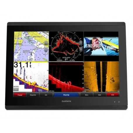
- Premium full HD touchscreen features Garmin’s highest resolution display.
- It’s compatible with premium maps and charts for the best in Garmin navigation.
- Easily build your marine system using the best of network connectivity.
- From ANT® technology to Wi-Fi® networking, there are countless ways to connect to your system.
- Take the guesswork out of sailing with clear laylines and more — right on the screen.
- With SmartMode™ station controls, everything is designed to give you quick, one-touch access to the information you need.
FULL HD TOUCHSCREEN
The sunlight-readable, anti-glare display includes an auto-dimming feature for low light or nighttime use. An in-plane switching LCD display provides consistent, accurate colors from all angles.
SIMPLE, ATTRACTIVE MOUNTING OPTIONS
Install multiple displays with the low flush-mount profile, or flat mount them edge-to-edge for a sleek glass helm look. The maximum glass design puts a powerful, networked helm at your fingertips.
GARMIN MARINE NETWORK
If you have multiple compatible Garmin devices on your boat, you can share information — such as maps, user data, radar and IP cameras — among them.
NMEA 2000® AND NMEA 0183 NETWORKS
Connect to autopilots, digital switching, weather, your FUSION-Link™ audio system, media, VHF, AIS and more from one screen.
ACTIVECAPTAIN® APP
Built-in Wi-Fi connectivity pairs with the free all-in-one mobile app for access to the OneChart™ feature, smart notifications1 , software updates, Garmin Quickdraw™ Community data and more.
BUILT-IN CONNECTIVITY
It’s easy to connect to peripheral devices with built-in Wi-Fi connectivity, ANT technology, four wired Ethernet ports, NMEA 2000, HDMI and USB ports with complete network compatibility.
ONEHELM™ FEATURE
This feature brings together all the operations and capabilities of third-party devices, such as EmpirBus™ digital switching, on one screen.
SMARTMODE STATION CONTROLS
Get quick, one-touch access to the information you need to ease high-stress situations such as docking. You can incorporate networked sonar, radar, cameras, media and more.
CONNECT WITH RADAR
You can add your choice of compatible Garmin marine radar, including our powerful xHD2 open-array radars, GMR Fantom™ open-array radars with MotionScope™ technology or xHD dome radars.
CAMERA SUPPORT
Garmin supports select FLIR cameras for surveillance and situational awareness on your vessel. And with our Surround View Camera System, get live bird’s-eye view video plus 360-degree helm visibility.
GARMIN SAILASSIST™ SAILING FEATURES
View laylines, race start line guidance, enhanced wind rose, heading and course-over-ground lines, true wind data fields and tide/current/time slider, wind angle, set and drift, wind speed, polars and more.
PRELOADED MAPPING
Experience unparalleled coverage and detail with preloaded BlueChart® g3 coastal charts and LakeVü g3 inland maps featuring integrated Garmin and Navionics® content and Auto Guidance technology.
OPTIONAL CHARTS AND MAPS
Bring a fresh new look and feel to your chartplotter with optional Garmin Navionics+™ or premium Garmin Navionics Vision+™ cartography featuring integrated coastal/inland content, access to daily updates, Auto Guidance+™ technology2 and more.
QUICKDRAW CONTOURS
The free, easy-to-use software feature instantly creates your own personalized HD fishing maps with 1’ contours. There’s no special surveying expertise required. You just fish while it creates maps (requires transducer, sold separately).
MULTIPLE DEPTH RANGE SHADING
Designate up to 10 different depth ranges — each with its own color. This makes it easier to view target depths at a glance.
FAST, RESPONSIVE 10-HZ GPS
Your position and heading are refreshed 10 times per second to make your movement on the screen more fluid. Plus, GPS 24xd provides dual frequency precise location accuracy3 to within 1 meter.
SAILING POLARS
Use the polar table to see key data, including how fast you should go at a certain wind angle and speed — so you know whether you need to adjust sail trim.
SONAR COMPATIBILITY
Find more fish when you pair with GSD™ 26 CHIRP professional sonar, GSD 24 advanced sonar, GCV™ 20 or GSD 25 ClearVü and SideVü scanning sonars or Panoptix™ all-seeing sonar.
IN THE BOX
- GPSMAP 8617
- Trim piece snap covers
- GPS 24xd NMEA 2000 (with pole mount, flush mount and under deck mount adapters)
- Protective cover
- Flush mount hardware
- Power cable
- NMEA 2000 2 m backbone/drop cable
- NMEA 2000 6 m backbone cable
- NMEA 2000 power cable
- NMEA 2000 T-connector & terminator kit
- Documentation
General
DIMENSION 16.5" x 12.1" x 2.8" (41.9 cm x 30.7 cm x 7.1 cm)
TOUCHSCREEN YES
DISPLAY SIZE 14.4" x 9.1"; 17.0" diagonal, 36.6 cm x 23.1 cm; 43.2 cm diagonal
DISPLAY RESOLUTION 1920 x 1200 pixels
DISPLAY TYPE FHD, IPS
WEIGHT 11.48 lbs (5.21 kg)
WATERPROOF IPX7
MOUNTING OPTIONS Flush or flat
Maps & Memory
ACCEPTS DATA CARDS 2 SD Cards (with Garmin SD card reader accesory)
WAYPOINTS 5000
TRACK POINTS 50,000
TRACKS 50 saved tracks
NAVIGATION ROUTES 100
Sensors
NMEA 2000 COMPATIBLE YES
NMEA 0183 COMPATIBLE YES
Built-in Maps
BUILT-IN AUTO GUIDANCE YES
BLUECHART (COASTAL) YES
LAKEVU (INLAND) YES
(SOUNDER) TIDE TABLES YES
Optional Map Support
LAKEVÜ G3 YES
LAKEVÜ G3 ULTRA YES
GARMIN NAVIONICS+™ YES
GARMIN NAVIONICS VISION+™ YES
(SOUNDER) TOPO YES
STANDARD MAPPING YES
GARMIN QUICKDRAW CONTOURS YES
RASTER CHART SUPPORT YES
Chartplotter Features
SMART MODE COMPATIBLE YES
AIS YES
DSC YES
SUPPORTS FUSION-LINK™ COMPATIBLE RADIOS YES
GSD BLACK BOX SONAR SUPPORT YES
GCV BLACK BOX SONAR SUPPORT YES
ACTIVECAPTAIN® COMPATIBLE YES
GRID (GARMIN REMOTE INPUT DEVICE) COMPATIBLE YES
WIRELESS REMOTE COMPATIBLE YES
SAILING FEATURES YES
SPOKEN AUDIO ALERTS YES
ONEHELM SUPPORT YES
Sonar Features & Specifications
DISPLAYS SONAR YES
TRADITIONAL SONAR (DUAL FREQUENCY/BEAM) Yes (with external black box, sold separately)
CLEARVÜ yes (with GCV™ black box, sold separately)
(SOUNDER) SIDEVÜ yes (with compatible black box sonar)
PANOPTIX™ SONAR YES
LIVESCOPE YES
Connections
NMEA 2000 PORTS 1
CONNECTIONS NMEA0183 INPUT PORTS 4
NMEA 0183 INPUT (TX) PORTS 2
VIDEO INPUT PORTS 1 (BNC composite); 1 HDMI (HDCP compliant)
VIDEO OUTPUT PORTS 1 HDMI
J1939 PORTS 1
GARMIN MARINE NETWORK PORTS 4
USB PORTS YES
BLUETOOTH® CALLING YES
ANT+ (CONNECTIVITY) YES
GARMIN WI-FI NETWORK (LOCAL CONNECTION) YES
Electrical Features
POWER INPUT 10-35 Vdc
TYPICAL CURRENT DRAW AT 12 VDC 2.8 A
MAXIMUM CURRENT DRAW AT 12 VDC 3.5 A
MAXIMUM POWER USAGE AT 10 VDC 40W